🌍 LiDAR Technology Explained: The Laser-Powered Revolution of the Modern World 💫
👁️ What Is LiDAR?
Imagine a world where machines can “see” their surroundings with laser-like precision — detecting every curve of the road, every leaf of a tree, or even the smallest rock on the ground.
That’s the power of LiDAR, short for Light Detection and Ranging.
In simple terms, LiDAR is a remote sensing technology that measures distances using laser light. It works by sending out rapid laser pulses — sometimes millions per second — and calculating how long it takes for the light to bounce back after hitting an object. This creates a 3D map (or “point cloud”) of the environment with extraordinary accuracy.
Think of it as a bat using sonar to navigate in the dark — except LiDAR uses light instead of sound. 🌈
⚙️ How LiDAR Works — Simplified
At its core, every LiDAR system has three essential parts:
-
Laser emitter: Sends out laser pulses toward an object.
-
Scanner and receiver: Collects the reflected light when it bounces back.
-
GPS or IMU (Inertial Measurement Unit): Tracks the system’s exact location and orientation.
By calculating the time of flight (ToF) — how long the laser takes to return — the system determines the distance to the object. Multiply this by millions of pulses per second, and you get a detailed 3D picture of your surroundings.
👉 Formula:
Distance = (Speed of Light × Time of Flight) / 2
💡 A Quick History of LiDAR
LiDAR isn’t exactly new — it dates back to the 1960s, shortly after the invention of the laser. NASA first used LiDAR in the Apollo 15 mission (1971) to map the moon’s surface.
Over the decades, it evolved from bulky, expensive scientific instruments into compact, affordable systems used in:
-
Self-driving cars 🚗
-
Drones and aerial mapping 🚁
-
Robotics and automation 🤖
-
Archaeology and environmental monitoring 🌳
-
Smartphones and gaming devices 📱
Today, companies like Velodyne, Ouster, Luminar, and Innoviz are leading the charge in making LiDAR smarter, cheaper, and faster.

🧠 Types of LiDAR Systems
LiDAR isn’t one-size-fits-all. Depending on where and how it’s used, there are a few main types:
1. Terrestrial LiDAR
Mounted on tripods or vehicles to scan buildings, roads, and landscapes — perfect for architecture, archaeology, or construction.
2. Aerial LiDAR
Installed on planes or drones, this type maps large areas like forests, mountains, or floodplains. It’s ideal for environmental and geological studies.
3. Mobile LiDAR
Used on moving vehicles (like survey cars or AMRs). It continuously scans as the vehicle moves — creating detailed 3D maps in real time.
4. Bathymetric LiDAR
A specialized form that uses green lasers to penetrate water and measure seabeds or riverbeds — essential for coastal studies and underwater mapping. 🌊
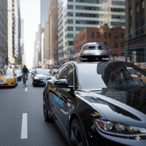
🤖 LiDAR and Autonomous Vehicles
If there’s one industry where LiDAR truly shines, it’s autonomous vehicles (AVs) — the self-driving cars of tomorrow. 🚘
LiDAR acts as the eyes of these vehicles. It provides real-time 3D data about the car’s surroundings — other vehicles, pedestrians, obstacles, and road markings — even in low light or foggy conditions where cameras struggle.
Many of the world’s top autonomous vehicle projects, including Waymo, Cruise, and Tesla’s competitors, rely heavily on LiDAR for safe navigation.
Key Benefits:
-
360° environmental awareness
-
Accurate distance and shape detection
-
High precision even in darkness
-
Instant object tracking and avoidance
With LiDAR, cars don’t just “see” — they understand their surroundings.
🏗️ LiDAR in Construction and Urban Planning
Cities are growing fast — and LiDAR helps us plan smarter. 🏙️
Architects, engineers, and surveyors use LiDAR to create digital twins of cities — detailed 3D models that help plan new infrastructure or monitor building health.
LiDAR scans can detect subtle shifts in a structure, spot potential hazards, or even model how sunlight affects a neighborhood throughout the year.
Example:
-
In Singapore, LiDAR data is used to manage urban trees and monitor canopy coverage.
-
In Dubai, city planners use drone-based LiDAR to model skyscrapers and road networks in stunning detail.
The result? Smarter, safer, more efficient cities. 🌆
🌿 LiDAR for Environmental Science
Beyond technology, LiDAR is quietly helping save our planet. 🌍
Environmental scientists use LiDAR to measure forest density, tree height, and biomass, helping track deforestation and carbon storage.
It also plays a crucial role in disaster management — from mapping flood zones to predicting landslides or measuring glacier retreat.
For example:
-
NASA’s GEDI mission uses LiDAR to monitor global forest structures from the International Space Station.
-
Australia uses aerial LiDAR for bushfire risk mapping and habitat conservation.
This laser-powered tool is not just about technology — it’s about understanding and protecting Earth’s ecosystems. 🌳✨
🕵️ Archaeology and Cultural Heritage
LiDAR has even rewritten history — literally! 📜
Archaeologists use aerial LiDAR to uncover hidden ruins buried under forests or soil. It can penetrate dense vegetation and reveal man-made structures invisible to the naked eye.
A famous example is the discovery of lost Mayan cities in Guatemala, where LiDAR revealed thousands of ancient structures hidden beneath jungle canopy — all without a single shovel hitting the ground.
That’s the beauty of LiDAR: non-invasive exploration with jaw-dropping precision.
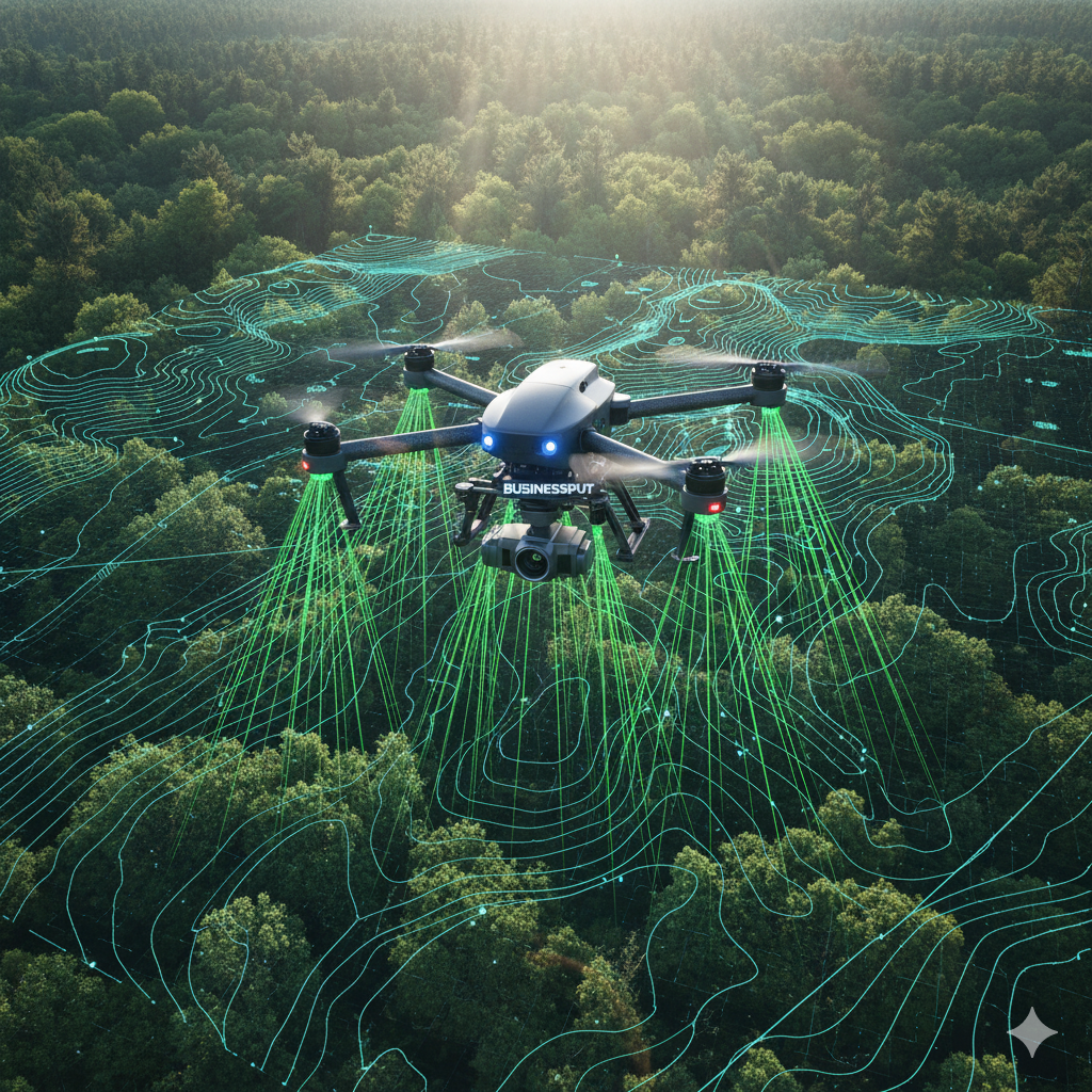
🛰️ LiDAR in Drones and Mapping
Pair LiDAR with drones, and you get an unbeatable combo. 🚁✨
LiDAR-equipped drones can cover huge areas quickly, capturing terrain data for mapping, surveying, and agriculture.
Farmers use LiDAR to analyze crop heights and irrigation patterns. Geologists use it to study erosion and fault lines.
Because drones fly low and slow, they capture more accurate data than satellites — and with modern AI software, the results come in real time.
This has made LiDAR a must-have tool for mapping agencies, land surveyors, and environmental researchers worldwide.
📱 LiDAR in Everyday Devices (Yes, Even iPhones!)
You might not realize it, but LiDAR is already in your pocket. 📲
Apple introduced a LiDAR Scanner in iPhones and iPads starting with the iPhone 12 Pro. This mini LiDAR helps apps measure rooms, create AR experiences, and improve low-light photography.
For instance, interior designers can scan an entire room in seconds. Game developers use LiDAR to anchor virtual objects realistically in your environment.
It’s a glimpse into the consumer side of LiDAR, showing how laser-based sensing is moving from labs and vehicles to everyday life.
The Future of LiDAR — Smarter, Smaller, and Everywhere 🚀
Now that we understand what LiDAR is and how it’s shaping industries today, let’s explore where it’s heading — because the future of LiDAR is not just bright… it’s laser-bright. 💫
⚡ LiDAR vs RADAR vs SONAR — What’s the Difference?
LiDAR, RADAR, and SONAR all do something similar — they detect objects by sending out waves and measuring how long they take to return.
But what makes LiDAR special is the type of wave it uses and the precision it offers.
Here’s a quick breakdown:
| Technology | Wave Type | Common Use | Accuracy | Strengths | Limitations |
|---|---|---|---|---|---|
| LiDAR | Light (laser) | Mapping, robotics, cars | High (centimeter-level) | Detailed 3D imaging | Expensive, affected by weather |
| RADAR | Radio waves | Aviation, military, cars | Medium | Works in bad weather | Lower resolution |
| SONAR | Sound waves | Underwater navigation | Medium | Works underwater | Limited to water environments |
👉 In short:
-
RADAR helps airplanes and weather stations.
-
SONAR helps submarines and ocean explorers.
-
LiDAR helps robots and cars see the world in stunning 3D clarity. 🌍✨
🤖 LiDAR in Robotics and Autonomous Mobile Robots (AMRs)
LiDAR is the beating heart of modern robotics and automation.
In warehouses, Autonomous Mobile Robots (AMRs) rely on LiDAR to navigate safely — avoiding people, forklifts, and obstacles while moving goods with surgical precision.
Think of it as the robot’s “eyes.” The laser beams constantly scan the floor, shelves, and environment to create a live 3D map. When something moves in front of it, LiDAR helps the robot instantly react — stop, turn, or reroute.
Real-world examples:
-
Amazon Robotics uses LiDAR-equipped AMRs for warehouse logistics.
-
Boston Dynamics’ Spot robot dog uses LiDAR to walk, climb stairs, and map terrain.
-
AutoGuide Mobile Robots use advanced LiDAR to operate safely in factories and industrial spaces.
The result? Smarter, safer, and more efficient automation — with fewer collisions, faster delivery, and real-time decision-making. ⚙️
💰 LiDAR Costs: Getting Cheaper, Faster, and Better
When LiDAR first appeared in commercial use, a single unit could cost over $75,000. That’s why early self-driving cars were so expensive. 😅
But today, thanks to competition and innovation, costs have plummeted.
Now you can find high-quality LiDAR sensors for:
-
Industrial/robotic use: $3,000–$8,000
-
Drone mapping systems: $2,000–$5,000
-
Consumer devices (like iPhones): under $1,000
Companies like Velodyne, Luminar, and Innoviz have driven prices down dramatically while increasing performance.
Even more exciting — solid-state LiDAR (with no moving parts) is on the rise. It’s more durable, compact, and ideal for mass production in cars and gadgets.
Soon, LiDAR won’t be a luxury tech — it’ll be a standard feature, just like GPS or cameras. 🚗📱
🧭 LiDAR in Mapping, Surveying, and 3D Modeling
LiDAR is redefining how we see and measure our world. 🌍
Surveyors now use drones with LiDAR to capture topography data in minutes instead of weeks. Engineers use that data to build roads, railways, and pipelines with incredible accuracy.
In architecture, LiDAR scans existing buildings to create digital twins — virtual replicas used for renovation, maintenance, and safety checks.
🌿 Example:
-
After earthquakes in Japan, LiDAR was used to analyze damage patterns and plan reconstruction.
-
In the US, LiDAR data helps FEMA identify flood-prone areas and update disaster response maps.
It’s fast, non-invasive, and astonishingly detailed — the future of mapping and design.
📱 LiDAR and AR (Augmented Reality): The Next Big Thing
LiDAR isn’t just about heavy machinery and high-end robots — it’s also changing entertainment and daily life.
With LiDAR sensors in smartphones, Augmented Reality (AR) is getting a massive upgrade. 📲✨
Now, your phone can “sense” the depth of a room, place virtual furniture with accurate scaling, or create 3D scans of real-world spaces for design, gaming, or education.
Apple’s ARKit and apps like 3D Scanner App and RoomScan Pro use LiDAR to make AR experiences more realistic and immersive.
Soon, as AR glasses and VR headsets evolve, LiDAR will help blend the digital and physical worlds seamlessly. 🌐💫
🧩 Challenges of LiDAR Technology
Of course, no technology is perfect. LiDAR still faces a few challenges before it becomes truly universal:
-
Cost: Although prices are dropping, high-end LiDAR remains costly for large-scale use.
-
Weather Sensitivity: Heavy rain, fog, or dust can interfere with laser signals.
-
Data Overload: LiDAR produces enormous amounts of data — sometimes terabytes per hour — which need powerful processors to analyze.
-
Privacy Concerns: Since LiDAR can scan and map private areas, ethical use and data security are key issues.
But the tech industry is moving fast. AI-powered filtering, sensor fusion, and smaller hardware are already solving many of these hurdles. ⚙️💡

🌈 Future Trends in LiDAR Technology
Here’s what the near future holds for LiDAR — and it’s fascinating:
🌐 1. Integration with AI
LiDAR data combined with Artificial Intelligence will allow machines to not only see but also understand what they’re looking at — classifying objects, predicting motion, and improving safety in autonomous systems.
🚗 2. LiDAR Everywhere in Vehicles
Soon, every level-3 or higher autonomous car will have multiple LiDAR sensors, integrated seamlessly with cameras and radar for full environmental perception.
🤖 3. Micro-LiDAR Chips
Companies are developing chip-sized LiDAR sensors — smaller than a coin — for smartphones, drones, and AR glasses. Imagine scanning an entire 3D environment with your glasses in real time. 👓✨
🏙️ 4. Smart Cities Powered by LiDAR
Urban infrastructure — traffic systems, street lighting, and surveillance — will use LiDAR to manage congestion, detect accidents, and improve safety with live 3D city mapping.
🌲 5. Climate and Space Exploration
LiDAR will continue to help monitor forests, glaciers, and even extraterrestrial terrain. NASA is already using LiDAR to map Mars and study ice layers on Earth’s poles.
🏢 Leading LiDAR Companies to Watch
Several global innovators are shaping the LiDAR market:
-
Velodyne Lidar (USA) – Pioneers in 360° spinning LiDAR systems.
-
Luminar Technologies (USA) – Developing high-range LiDAR for autonomous vehicles.
-
Ouster (USA) – Focused on digital, affordable solid-state LiDAR.
-
Innoviz (Israel) – Providing automotive-grade sensors to BMW and Toyota.
-
Quanergy (USA) – Known for LiDAR-based security and smart city solutions.
-
Leica Geosystems (Switzerland) – Leaders in survey-grade LiDAR for engineering and construction.
These companies are making LiDAR faster, smaller, and smarter than ever before — pushing the boundaries of perception technology. 🌐
💭 Ethical and Social Implications
As LiDAR spreads into cities, homes, and personal devices, ethical questions arise:
Who owns the scanned data? How should it be stored or shared?
Governments and tech companies must create clear privacy frameworks to ensure LiDAR is used responsibly — especially in public spaces and personal gadgets.
Balancing innovation with ethics is key to making LiDAR a force for good in society. 🌱
🌟 Why LiDAR Matters
LiDAR is more than just a sensor — it’s a revolution in perception. 👁️✨
From helping robots navigate warehouses to guiding self-driving cars, from revealing lost civilizations to powering your smartphone camera — LiDAR is quietly transforming how we see and understand the world.
It stands at the intersection of light, data, and intelligence — three pillars of the next technological era.
As prices fall and applications grow, LiDAR will soon be as common as GPS or Wi-Fi — embedded in our devices, vehicles, and cities, making the world smarter, safer, and more connected. 🌎💫